
Google Earth is a powerful program. It provides a 3 dimensional view of the earth’s surface and is designed to allow users to embed their own data and share it with others on the Google Earth platform. And it’s free. You just need to know how to take advantage if it.
I find it invaluable for enhancing my photography when there is a spatial component (i.e., when the location of the photos is important). By incorporating my images in Google Earth or in it’s companion program Google Map, I can add the geographic dimension to enhance the viewer’s experience and better communicate my client’s message. I’ve made use of this many times from preparing proposals for multi-site assignments to coordinating a large regional project with other photographers.
Most recently, Google Earth was the perfect application for a environmental photography study. The assignment was to photograph a certain type of geology in various locations of NJ in order to illustrate the orientation of the fractures. The conventional way to do this is to simply take the photos and then mark the locations on a map. This is effective but the viewers have to jump back and forth between map and the photos and cannot virtually travel around the region like they can with Google Earth.
Using Google Earth is fun and introduces the “WOW” factor. If you’ve ever used Google Earth you know how it flies in and around the globe to various areas and can not only see not only the locations but can give you a 3 dimensional rendering that showing the hills and valleys of an area along with a seamless aerial photo that shows all the features on the ground.
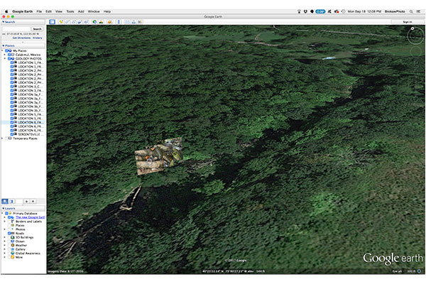
This is an example from my recent project showing the location of three photos that were taken in a stream valley. The photos are georeferenced to the exact locations they were taken and each image is also annotated with additional data relative to the project. On the left side of the screen shot is a menu of other photos. By simply clicking on any one of these menu items, a viewer is magically transported to the region where the photo was taken.
The process for incorporating photos and data into Google Earth takes several steps but is certainly doable. Once completed, the whole project can be saved as a single file and shared with others through email or even embedded on a website. I’d love to hear your thoughts on ways to incorporate this process for your business whether it’s marketing, sales or operations. Feel free to leave a comment or contact me at Bill@BrokawPhoto.com
‘